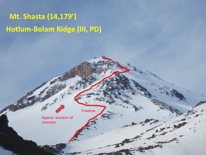
Sunday, June 26, 2016

Teresa becomes an alpinist -- Petit Griffon (13,720', II, steep snow, 5.7)


Teresa, about to become an alpinist
Me - "Do you want to go climb this thing in the little lakes valley? Its a bit like the Dorion tower, but at 13,000 feet"

Teresa - "Sure, I love that area"

Me - "Its going to involve snow climbing, so you'll need crampons and an ice axe"

distinct pause

Teresa - " Hmmm, well, ok"

Teresa has just signed on to becoming an alpinist. What's alpinist? Here's my definition:
- Technical climbing (5th class) in the mountains, often with massive approaches and/or snow and ice climbing. 

Although Teresa is a great rock climber, she has been hesitant to do anything that involves snow and ice. Finally, she agreed. 

Our objective - Petit Griffon, a rock spire at 13,000' that sits in beteeen Mt Mills and Mt Abbott. It involves over 1000' of snow climbing, and three pitches of technical rock climbing to the summit.
Our objective - Petit Griffon -

We headed up the east side of the Sierras Thursday night, picked up our permit in Mammoth Lakes, then drove to the trailhead down rock creek road. We woke up bright and early, realized we had forgotton coffee, so drove back to Mammoth, rectified that mistake and were on the trail by 9am.  Right away, we were gifted with magnificent alpine views. 


Views of Bear Creek Spire
We headed up towards Mono Pass, then Ruby Lake. We crossed a stream, then time for cross country travel. It was not long before we were at the snow line.


Don't fall in Tese!
Snow fields
We had planned to climb the route on Friday, but Teresa started to feel a bit of AMS (acute mountain sickness) from the altitude, so we decided to make a camp, acclimate for the night, and try climbing it in the morning.

Not feeling so hot. Altitude sickness is a bummer
We set a nice camp around 11,000' just below lake Mills. And had a relaxing afternoon, resting, acclimating, and enjoying the stunning location.

Now that is a nap
nap time selfie
Afternoon diversions
 We both got a solid 10 hours of sleep! And were up and back on the approach to the climb around 8 am.

On the approach. Mt Dade, Mt Abbot and Petite Griffon in the back ground.
Almost there...
 We got to the base of the snow couloir below the climb, 1000' of 40 degree snow slopes. We put on our crampons, busted out the ice axes and up we went. Teresa's first experience with the tools of the alpinists trade. The upper part of couloir was in the shade, so it was very cold, and quite icy. I'm glad we had crampons. We reached the notch just below the tower, and got our first views of the climb.

Crampons and ice axe.

In the shade, at the notch.
Looking up at our route
 As I racked up, a couple of other climbers showed up. Strangely enough, we had actually met one of them before! His name was Charlie, a computer guy from Palo Alto, who we had met at the base of Snake Dike earlier in May. Small world our little alpine climbing community. His partner, a Spanish climber showed up a few minutes later.

I headed up first, a 5.6 corner crack system, my fingers were numb from the cold, making the crack seem much harder! Then a belay at a flake, and a weird traversing, down-climbing 4th class pitch.


At the second belay


Somewhere on the climb. Bomber cam anchor to the left
Then the crux pitch, a wild looking 5.7 crack with 300' of air below. Wildly exposed, but super fun, well protected climbing.


Leading up pitch 3. Scary, but so much fun
Then summit time! The summit was amazing, a perfectly flat, coffee table sized block. Amazing. We looked in the summit register, we were the first climbers to summit in 2016! Unlike some Sierra peaks, this one is not frequented very often. There was even a fragment of the original register, which contained the names of the first ascensionists in 1964. 


Summit victory! Teresa the alpinist!


Original summit register! First or second ascent
We waited for Charlie and his partner to summit, chilled with them for a few minutes, and to make our descent quicker, we teamed up and tied our ropes together to make the rappels quicker.

We then rigged another rappel to quickly bypass the steeper bits in the snow couloir.

rap down that couloir
We said our goodbyes to Charlie and Friend. Very nice guys, I hope we run into them again sometime. Its always nice to have more partners for alpine adventures! 

Bye Charlie and friend!
We walked back to our camp, rested for a while, then I foolishly spilled our Deluxe Kraft Dinner. So we opted to walk out and get pizza in Mammoth. 
Amazing climb, in a stellar location. This is why I love living in California, and why I LOVE alpine climbing. I think maybe I hooked Teresa on alpinism, what's next for us?

Teresa the alpinist.


Wednesday, June 22, 2016

Mt. Rainier -- Attempt on Kautz Glacier

I am by nature a cautious person, I tend not to take what I consider to be unnecessary risks. I wonder if sometimes my cautious nature holds me back? 

This past weekend while climbing a big peak, I made a hasty decision, it resulted in us not summiting, was it the correct choice? What lessons can I take from the experience? How do I weigh the risks associated with alpinism with the reward of standing on the summit?

Myself, Troy and Michael headed up to the Pacific Northwest to try and climb the Kautz glacier route on Mt. Rainier. The route involves crossing 2 glaciers, 400-600' of moderate technical ice climbing, and over 9000' of elevation gain on the most heavily glaciated mountain in the lower 48.

Mt Rainier in its glory. Photo credit: Troy K.
On Saturday morning at 5 am I picked up Troy, and we began the 14 hour drive to Mt. Rainier national park. Michael was already in Seattle and would meet us at the trailhead. As we headed up the I5 the weather for progressively worse. A huge storm was pounding the Pacific Northwest. Not an auspicious start to the trip.


Raining on the way to Rainier
The forecast called for clear skies for the next couple of days. However, the summit of Rainier had received over a meter of fresh snow, conditions were uncertain, and avi danger was high. But the blue skies and warm temps had us smiling as we packed up, picked up our climbing permits and headed off down the trail to the mountain.


Blue skies warm temps Nice way to start the day. Photo credit: Troy K.


Troy - always stoked to climb

Early on the approach, we had to cross the Nisqually glacier, which is on the Southwest face of the mountain. We roped up and got to put that glacier travel training we did together into practice.


Crevasse on the Nisqually. Photo credit: Troy K. 

The crevasses on the glacier are very small for the most part, but because of the recent snow were totally covered up. It was a small shock when Michael punched through one of the small crevasses, just his leg sinking in. Sort of funny, but a very poignant reminder that there is a very real possibility that one could fall into these deadly features, with more drastic consequences than a simple posthole. 


Snow field above the Nisqually. Photo credit: Troy K.


On the ascent. Photo credit: Troy K.

After the glacier crossing, it was ~5000-6000' of slogging up snow slopes and rocky ridges. It would have been boring if it were not for the absolutely stunning scenery. This is why I climb mountains, they are the most beautiful places in the world. Photos just don't do them justice, but nonetheless, have a look at what the lens can capture. The following are credit to Troy K. Thanks Troy for being photographer on this mission!


Roped on the ridge
Upper section of the Nisqually glacier


Michael on steep snow. Photo credit Troy K.

One we reached the Turtle snowfield, there were signs of recent avalanches, so we traversed onto rocky volcanic choss to avoid the objective hazards posed by the snow fields. 


On the rocky ridge. Photo credit Troy K.


Recent avalanche
We reached our high camp, called Camp Hazard which sits below the ice cliffs of the Kautz glacier, very close to the technical part of the climb. It took us about 7-8 hours to gain the 6000' to the camp.

On the way up we passed several parties that were bailing, no one had been abel to make it past the ice chute above Camp Hazard because of all the recent snow fall. 

 Normally that kind of an approach would not have been a big deal for me, but I was completely wasted. I am not sure if it was altitude, or over-training. I have decided for the next few weeks to taper all my training and see if I regain my fitness. 

We built our camp, and began the long process of melting snow for water. 


Portrait of an overtrained, wasted climber. Photo credit - Troy K.
Portrait of a stoked climber. Photo credit - Troy K.
Portrait of an inexhaustible climber - Photo credit - Troy K. 
Comfort at Camp Hazard - Photo credit Troy K.
Ice cliffs above Camp Hazard


Troy and the camp kitchen

We woke up at 2:30 am and were on the way to the climb by about 4 am. We used a fixed rope to traverse a narrow ledge, then made out way to the ice chute. We roped up, and started simul-climbing the chute. I led, leaving 1-2 pieces of pro in between us once things started to get steep. 


Off we go.


Simul climbing the first ramp
The chute levels off a bit, then there is another few hundred feet of increasingly steep alpine ice. The normal approach would be to walk up the snow in the centre of the chute, but it was waist deep, so we climbed up the side of the serac instead, and continued to simul-climb.


Simul climbing the first chute - Photo credit Troy K. 


Troy starting up the side of the serac

As the ice got steeper, I plugged in an ice screw belay, and we pitched out the last steep 45 meter ice pitch. The weather became increasingly bad as we got higher. I was leading AI2+/3 ice, with a 50 lb backpack, at 11,000' in a white out snow storm. New experience for me.  When I topped out at the top of the pitch, I could only see about 5 feet in front of me. 

The I heard shouts, and a party of 5 climbers was bailing. They had been up to 13,000', and had been travelling for hours in a complete whiteout, unable to see anything. I made the decision to rap out as well. I had no interest in navigating a dangerous crevassed glacier up above in a complete whiteout.  Down I went raping off of ice horns. 


Dealing with ropes in the white out - Photo credit Troy K.

Troy and Michael were freezing cold, from waiting for me to lead,  so we headed down. A combination of raping off of snow bollards, ice horns and down climbing had us back to camp Hazard. Of course the weather cleared up once we were back to camp, although the summit stayed in a cloud for the entire day.

A long 6-7 slog back down to the trailhead. Beautiful views the entire way.


Mt Adam off in the distance
Heading down. Photo credit - Troy K. 


Views on the descent
On the way down, and a couple days after the climb, I was really torn up inside by my choice to bail, especially since things cleared up afterwards. 

Did I make the right choice? Was I too cautious this time? Maybe I should be prepared to take greater risks in the mountains? Is it worth it?

Although I think it was the safe choice to make, given the information at the time, I still feel like I need to be prepared to take greater risks.

However, what I really regret is making the choice by myself, and not really consulting with Michael and Troy. This is what is bothering me the most. 

So my lesson here is next time things are looking dicey, even if I am alone at the sharp end of the rope, I will make sure to consult with my partners before deciding anything. 

Summiting is not everything, and I took a lot away from this trip. This was my first attempt at a larger peak that required technical ice climbing and glacier travel. I feel much better prepared for Mt Athabasca later this summer, and to go back to Rainier in the future.

Monday, June 6, 2016

Mt Shasta (14,179') - Hotlum-Bolam Ridge

Hotlum-Bolam ridge 
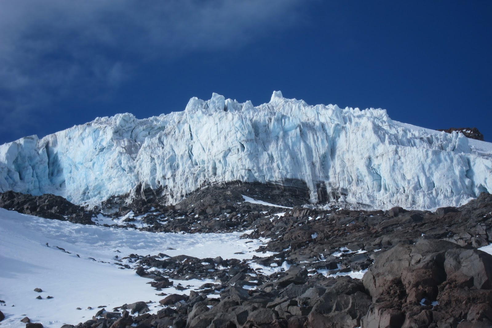
Mt. Shasta is one of the 12 California 14ners (peaks above 14,000'), and is at the southern terminus of the Cascade range. Unlike most California mountains, Shasta is a volcano, and is heavily glaciated, having 7 glaciers, including the largest and most voluminous glaciers in California.

North side of Mt. Shasta (left) and Shastina (right)
Spring and early summer are the best times to climb many of the routes on the mountain, when the snow is well consolidated, but not melted out. 

My plans to go rock climbing in Shuteye were put on the shelf when a last minute opportunity to climb the mountain with Richard Cobb, and his friend Devin presented itself. We planned to climb the Hotlum-Bolam ridge. Considered a "intermediate" route, it  ascends steep snow slopes and avoids the glaciers, making a safe choice. Also, being on the north side of the mountain, it avoids the massive crowds of tourist climbers that go up Avalanche gulch from the south. 

I drove up to Sacramento, picked up Richard and Devon, and headed to the north side of Mt. Shasta, arriving at the Northgate trailhead at midnight.


We woke up at 4:30 am, giving us only about 4 hours sleep. A little rough. We started up the approach trail. It was a really rough start, I felt like crap. My mind was swirling with doubts and thoughts of failure. After a little while, we cleared the tree, and entered a flat spot at about 10,000', which marked the start of the ridge. We passed a few friendly ski mountaineers on their way up the ridge as well.


Getting ready to go at the trailhead. Photo credit: Richard C.


Skiers on the approach to the ridge.
We cruised up some snow slopes below the ridge proper, then traversed across steep snow slopes to gain the chute to the left of the ridge. Its important to not directly ascend below the snow chute, because there is a crevasse below the chute. This time of the year its likley safe to cross the snow bridge, but why take the risk of falling in? 


Devon starting to traverse
We climbed the chute, then took a break on a nice boulder at the top of the chute. From out rest spot, we had nice views of the headwall above the glacier, and I could spy the Hotlum ice chutes (which I intend to climb next time!)

Break time
Head wall.
A flat spot, then up a icy slope heading towards the summit. Near the top we got sniffs of sulphur, there was some rock fall, and some cool looking features near the top of the slope.


Richard arriving at the top of the icy slope
Rock tower

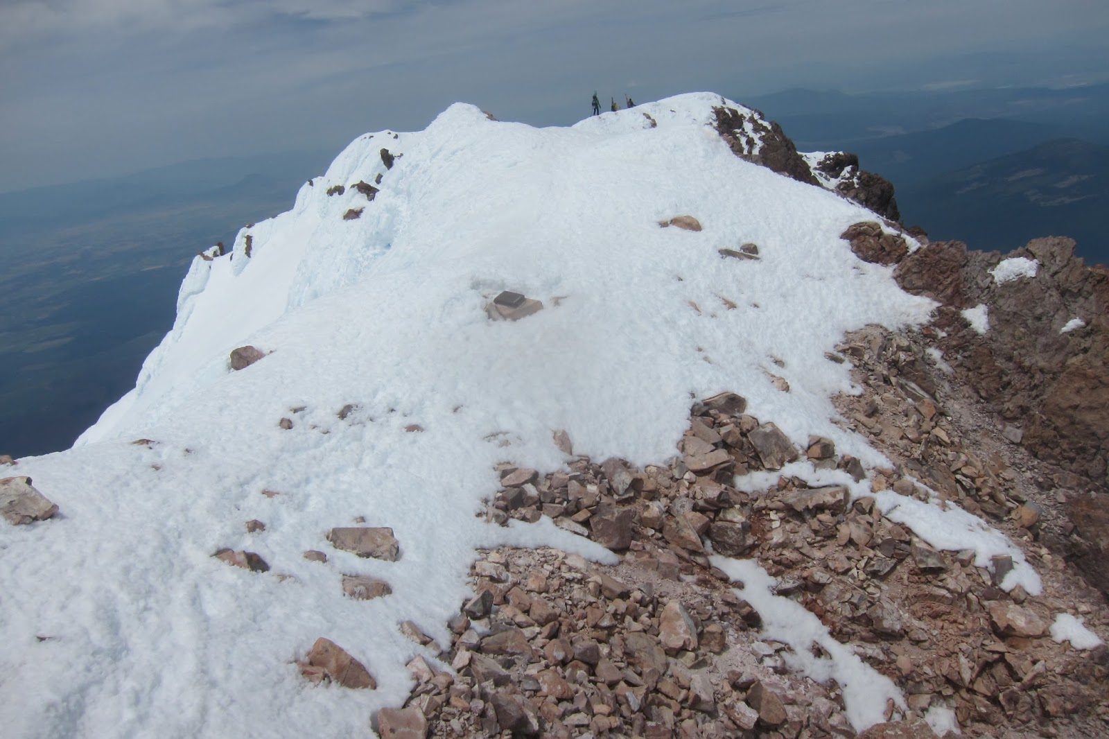
After the slope it flattened out again, and we headed around the false summit, then were smashed by hurricane force winds as we neared the summit. We also saw the crowds of climbers summiting from Avalanche gulch.


Almost up

And then summit time. Woot woot! 

Summit!

Richard and Devin. Classic summit pose

We found a nice sheltered spot to rest. I cooked up some soup (the windboiler works at 14,000' in the wind. MSR sponsorship?).


Windboiler at 14K


Richard. Alpinist nap.


We began the descent, retracing our steps down the ridge.


Devin on the descent
The snow conditions were perfect for glissading. So we slid down over 3000' on our butts! Super fun! 


Glissade! Woot!

We were back to the cars by 5:40 pm. 12 hours car-to-car. Not too bad. 
Overall super fun trip. This time the altitude slowed me down, but I did not feel nearly as sick. I think I am ready to move on to more technical mountains at altitude. Looking forward to Mt. Rainier in a couple of weeks!