Tuesday, April 26, 2016

North East Couloir of Mt Langley (14,026', class 3, steep snow)

Above 13,000' without any acclimatization my body was simply not receiving enough oxygen for the exertion of climbing. I was nauseous, light headed, and moving at a glacial pace. Every step I stopped closed my eyes, almost falling asleep where I stood. The scene went something like this:

Plunge the ice axe in, kick steps with crampons, breathe, close eyes.... "what the fuck I am doing? what's wrong with me, how am I ever going to make it? "  Then repeat.

I loved every single minute of the struggle. More on that later. 

This weekend I met up with Richard Cobb,  to climb the NE couloir of Mt Langley. The mountain is the southern most of the California 14ners. It sits just above 14,000 feet in elevation, and with more than 7,000 feet of elevation gain from the trailhead is a real beast of a climb. We had originally planned to climb the classic Casaval ridge of Mt. Shasta, but a nasty storm there, sent us to Langley as a back-up plan.

North East Couloir of Mt. Langley.

 We met at Tuttle Creek campground in Lone Pine, around 10 pm, on Friday night. We debated the merits of going up and setting a camp at 10,000', or just going car-to-car in a single big push. 
We decided on a single big push. I have not tried going straight to 14,000' with no acclimatization before, would I be able to do it?

For me that's the fun of climbing mountains, pushing myself, searching for my limits. Its not supposed to be easy.

I set-up in the back of the Subaru, and prepared for a 3 am start the next day.


I'm 35 years old, and sleeping in the back of my car.
We were up at 3:30am, and on the trail by 5 am. The first mile is easy, up an old road that eventually becomes a trail, leading to an Ashram built in the early 1930s. An interesting piece of California history


Tuttle Creek Ashram
There were a few people camped out in the Ashram, we were there around 5:30 am, and I am sure they were not too happy when we trounced through the building! We were to discover later in the day, on our descent, that they were there to party, so I feel less bad about disturbing them now!

In the early morning light we blasted up the approach trail, it was kind of a blur. We were moving really fast. Eventually we were into the a stand of foxtails, which in California means you are almost in the alpine. We also passed a few tents, other climbers who opted to do the climb in 2 days, rather than one. We also sighted some impressive rock walls, loaded with cracks. So many things to climb!


Foxtails


Crack anyone?
Once we were out in the open we could see the route, and other climbers off in the distance heading up to the couloir. The route looked super fun, and we were making such good time, that we got cocky, thinking we would be done this whole deal in less than 8 hours. Boy were we wrong. 


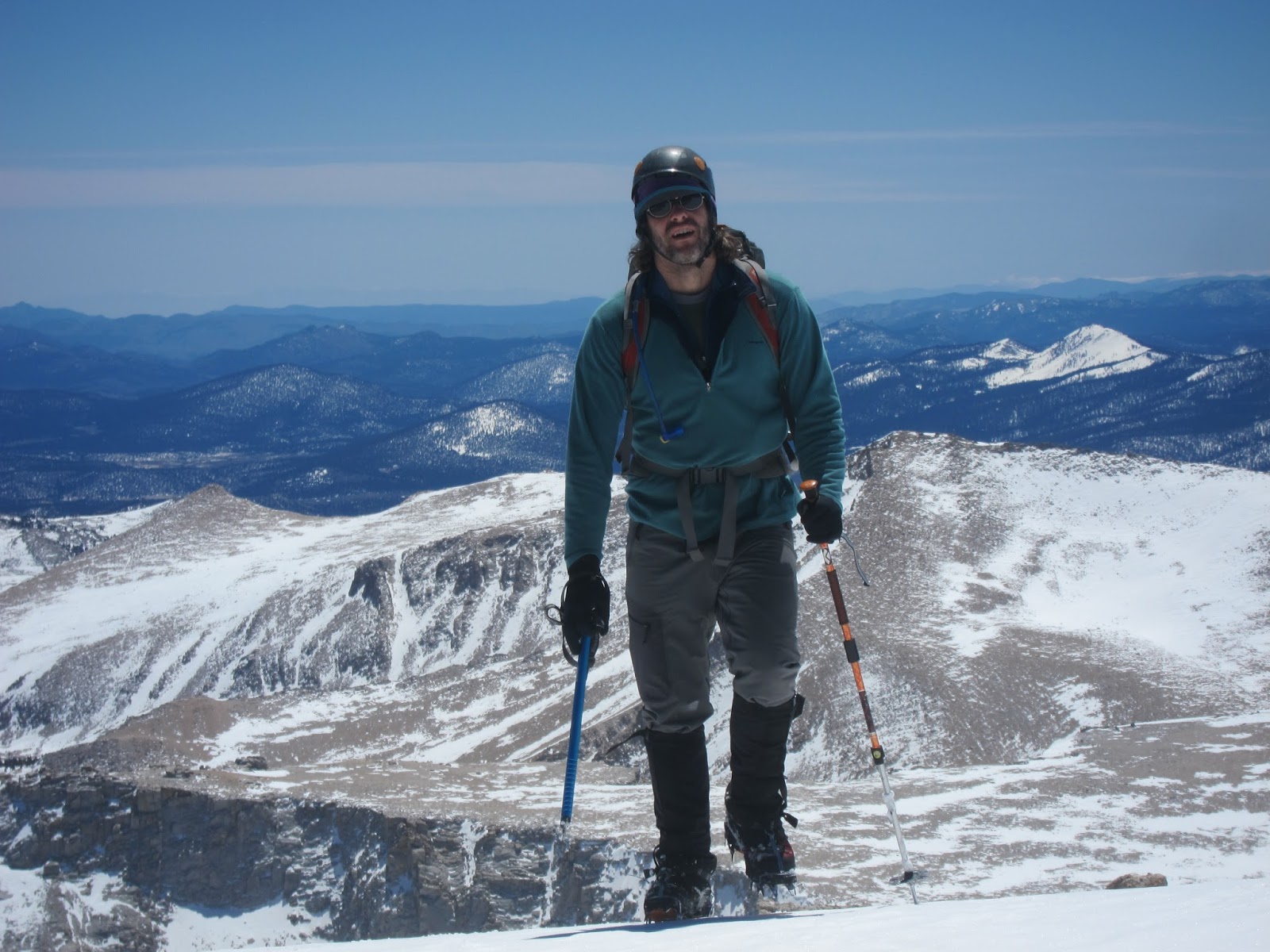
Me with our route in the background. Photo credit: R. Cobb.
Soon enough we were in the couloir. The snow was rock hard, making for super fun snow climbing. It was deceptively steep, I think the angle must have been around 35 degrees.


Start of the couloir. Photo credit R. Cobb
We headed up the long couloir, one of the climbers ahead of us turned around, and we passed a second, and then a third climber on the way up.


Richard, snow climbing master


Looking up the couloir

And then things started to slow down. The couloir was much longer than it looked, more than 2000', that's twice the height of the mountaineers route on Mt. Whitney. Above 13,000' the altitude really started to affect both of us. I was hit first, then Richard a bit later.  Having come straight up with no acclimatization, we simple were not getting enough oxygen for the exertion of the climb.  

Every step required a rest, nausea, light headedness set in. The only thing keeping us going was sheer will power. 


Richard climbing through the altitude sickness like a boss


 For me this is the best part of mountain climbing, struggling through the pain, exhaustion finding the will and energy deep within to continue. There is nothing else like it, rock climbing is fun, put alpinism forces you to find your inner truth. 
I am looking for the edge, how far can I go? How far can I push myself and my body? 

Right before exiting the couloir we ran into the final climber ahead of us. He was on the way down. He had failed to summit, after taking a nasty fall, self-arresting, and dislocating his knee. Luckily he was able to knock it back into place, so did not need any help.
A good reminder, than even easy climbs like this can be dangerous.

We crested onto the ridge, exiting the couloir. There was one final steep snow slope ahead of us.


Final snow slope to the summit


The final slope was steep, 40 degrees, and only maybe 400 feet, but it took us the better part of an hour to reach the summit plateau.


Richard reaching the summit


As always, the views from the summit were fantastic! One of the reasons to suffer up the steep slopes!


Summit views. Typical. 

Once on top, we both collapsed on a flat rock. I pulled out my parka, and entered the fetal position. We both napped for about 30 minutes. Very refreshing!


Nap time


That's weird. Photo credit: R. Cobb

Then time for the descent. It always seems like its going to be easy, but it never is. We down climbed the steep steps, then as we got lower were able to glissade some, speeding up the descent.


On the descent.

We were back to the car by 6 pm. 13 hours car-to-car, 7,000' elevation gain, 11 miles round trip. Awesome trip. I am pumped to go back into the mountains again, looking forward to the next one!

Sunday, April 17, 2016

Tree Route!!


Saturday I went to Shuteye, and banged out 10 pitches of climbing with Jared. The climbing was awesome, and Jared did super well, and it was tons of fun. However, I foolishly climbed routes I had previously done, so my climbing itch was not sated. Mental note: when stoke is high, start on the main objective! Luckily there was still Sunday so satisfy my addiction.

Teresa and I had planned to go for hike in Yosemite, but this week was free admission week, so it was going to be crazy there. I showed her the description for the Tree Route at Dome rock "best 5.6 in the USA", well that's an endorsement

Me - How do you feel about going to Dome Rock tomorrow? Its a 2.5 hour drive.

Teresa - Sounds fun!

Me - There is a possibility the road is not open , and we will have to walk in.

Teresa - That's fine

That' why I love my wife, 2.5 hour drive, possibility of failure drive to a closed road, and she is still down!

We had a late start on Sunday, hitting the highway at 9am. After a long drive, and a very twisty road, we ran into the being road closed! Teresa was undaunted. We had wanted to hike anyways, and with road closed, it was pretty much assured that we would have to climb to ourselves!

This is not a problem
The walk in was not that far, only about 35 min down the road. We found the sign pointing to the correct side road. Similar to Fresno Dome, you start at the top of the cliff, and walk down the side.


Good advice. Being the only humans nearby, nothing we had to worry about!

We headed down a drainage towards the base of the dome. In typical Cory fashion, I chose the wrong way, and we ended up on a level II bushwhack.

Cory style approach
We eventually found the base of the dome. We wandered along, admiring the terrific rock, and the bold looking routes!

This looks like a bad-ass climb.
After about 30 minutes we found the base of the "Tree route" We had some lunch, and headed up the best 5.6 in the country.

Start of the tree route. Perfect hand crack to start
The beginning of the climb was fabulous, an amazing handcrack, to a tree, then up some slabs to belay number one. The second pitch is the money pitch, 200' of finger sized crack. The thing took the same cam over and over again, so it was good practice in cam leap frogging.

Teresa on pitch 1

Start of the money pitch
The climbs was amazing, I fully endorse the "best 5.6 in the USA" designation. Its rare to have such great climbing at such an easy grade!

Teresa almost up pitch 2
Throughout the climb we also had terrific views of the Needles, which are just up the road from Dome Rock. I really need to head over there soon, and climb Voodoo Dome, looks soooo very good.

Views of the Needles
Pitch 4 is the "crux", a 5.6 slab. Since I had climbed a 5.10c and a 5.10b slab on Saturday, so this felt like a walk in the park


Before the crux
Soon, we were at the top. Such a great climb! The best part was Teresa's enthusiasm, and for once having a giant multi-pitch climbing dome all to ourselves!  The crux of the climb was the fire-ants biting me on pitch 1 and 3.
Did I bring enough cams?

Summit shot!

Another weekend, another little adventure. Next week its back into the alpine, for a shot at another 14,000' peak

Is this what life is all about?

Sunday, April 3, 2016

Mt Whitney, Mountaineers Route (14,505', class 3)

I had been thinking of doing a winter ascent of Mt. Whitney for a while, but a series of storms in January, and other priorities but it on the shelf. So instead of a winter ascent, a spring ascent of the mountaineers route was put into action, Michael was stoked, and suggested that one of his friends, Troy might also be interested. Michael is a strong climber who is pumped about venturing into the mountains, and Troy is an experienced ultrarunner/alpinist/mountain enthusiast.  Then of course me, the approaching middle aged professor who thinks he can still climb, a perfect team!

I picked up the boys, and we headed over to Lone Pine. A boring ~5ish hour drive across sage brush desert. Some people made wise use of the time in the vehicle.

Michael enjoying the ride to Lone Pine.
We camped at Whitney Portal (7850'), and had a relaxed morning start around 8 am. No need for alpine starts here. There was no snow at the portal, a sign that spring is full on in the mountains. We weighed our packs, mine came in at 36 lbs. Yikes! I don't think I have carried a pack that heavy in years, I guess all those layers add up, or I just brought too much stuff!

Gearing up at the Portal. Photo credit Troy K.


Start of the trail.


The trail starts out on the infamous Whitney swtichbacks, but then quickly diverged onto the North Fork of Lone Pine creek. The trail is shorter, but steeper then the regular Whitney trail. Thank goodness, I hate those endless swtichbacks. I much prefer just walking straight up a steep slope.  It was not long before we were into the snow line.

Approach trail. Photo credit Troy K.
Troy making it look easy, on the approach.
The approach to our planned camp at iceberg lake, is only 3.4 miles, but gains about 4300'. Honestly the hike in was not nearly as bad as I was expecting. The snow was well consolidated, so we didn't need snow shoes, and there were plenty of tracks to follow. We passed a bunch of people camped at lower boy scout lake, and continued on our way. The sun was blazing, and it was very hot out, not winter conditions!

View from lower boyscout lake

Once we passed upper boy scout lake, we passed a group of guided climbers, and then headed a short steep icy hill. The first time we had to bust out our ice axes and put the crampons on.

Short steep section on the approach. Photo credit: Troy K.


Above upper boyscout lake
We reached our base camp at iceberg lake which sits at 12,700' around noon. We set up camp, had some food and debated the merits of continuing on to the summit.  It was around 2:30 by the time camp was set, water boiled, food ate and the decision had to be made. A few other climbers were coming off the route, having failed to summit. We decided to wait or the next day, but in retrospect it would have been a piece of cake to have summited that day.
Troy provides scale, next to Mt Whitney. Our route takes the snow gully to the right.

Basecamp at Iceberg Lake (12,700')
We lounged around camp, basking in the warm sun, resting for the next day's climb. Almost felt like a day at the beach, except for all the snow, and the thin air giving me an altitude headache. We all took a nap in our tents.

Relaxing in my tent. What a view....

Michael demonstrates how to evade a sunburn
Soon the sun dipped behind the mountain, and the temperatures plummeted. It was well before freezing in no time. Where did those beach temps go?

Troy and Michael trying to stay warm
We were off to bed not long after sunset. Into our warm fuzzy sleeping bags. None of us slept very well. Apparently sleeping at an altitude of almost 13,000' is tough. I did some research and restless sleep is the norm at high altitude. A good experience to know what to expect for future high altitude climbs.

Cozy? Photo credit: Troy K.
We woke up around 7am, and had another lazy morning. A seemingly endless train of climbers marched passed our camp onto the climb, as we made our breakfast. I guess most people camp at lower elevation, but I am glad we stayed where we did. The climb starts with about 1600' of ~35 degree snow slopes, up a wide gully.

Michael coming up the start the route
We flew up the gully, and passed a few of the climbers who started before us. Soon we were onto some rock bands, and then crested onto a "notch".

Troy and Michael right before the notch
Above the notch there is about 400' of 3rd class climbing. Oh so fun. We headed up some easy rock, then onto a steep snow slope. This was the highlight of the climb, I just wished it was 2000' long instead of a mere 400'. We didn't bother roping up for this part, the climbing was easy and fun.

Troy climbing some of the 3rd class rock bands

Michael negotiates the crux
Looking down the final steep snow slope
After that summit time! Whoop! Only took is ~1.5-2 hrs to summit the mountain! Great to stand on top of the tallest peak in the lower 48 once again.

The boys relaxing on the summit

Summit views

Team summit shot! 

We were back to our base camp in about an hour, and then it was 3 hours hike back to the car. Overall an awesome trip.

I am super impressed with Michael and Troy as alpine climbing partners. They both have easy going personalities, drive to get to the summit, skill to get us there, fitness to push on, and most importantly super positive attitudes. I think there will be more peaks in our futures.

A few notes:

-This could have easily been done as a day trip. With the consolidated snow, and lighter packs, I think a one day ascent of the route would be something worth doing.

-The climb was way easier than I was expecting, the technical parts were short and easy, and although the mountain was tiring, I would not say I was pushed to my limit.

-Nutrition at altitude remains a struggle for me. The dehydrated Mountainhouse I brought was nauseating. I totally lose my appetite above 10,000'. I think maybe heartier soups, granola, and other liquid food to supplement my snacks might be the way to go. Snickers are like magic, I eat one of those and I am recharged for about 2 hours

-I need to drink more water!

-Equipment was overkill, I had too many layers. Next time, I'll trim it down somewhat.